Monday, February 22, 2016

trade route


Image for unlabelled figure
Map of spice routes from Southeast Asia to Africa and Arabia


;;;;;;;;;;;;;;;;;;;;;;;;

“He who controls the spice, controls the universe.” Such were the words uttered by the main character of the movie Dune based on the Frank Herbert science fiction epic of the same name. In the story, the spice was the lifeblood of a vast empire. For the leaders of this empire, it was essential that at all times ‘the spice must flow.’
The spice trade of the Dune movie was no doubt inspired by the historical trade in aromatics from ancient times to the present. At various periods in history,spices have been as valuable as gold and silver. According to a 15th century saying: “No man should die who can afford cinnamon.”
The aromatic substances were even more mysterious as they were connected in many cultures with the idea of a faraway paradise -- Eden. The Muslim writer al-Bukhari wrote that Sumatran aloeswood known as `Ud in Arabic filled the censers of Paradise. Ginger was the other major aromatic of Paradise in Muslim tradition. In the Travels of Sir John Mandeville it is said that the aloeswood of the Great Khan came from Paradise.
We will show that the famed spices which traveled from Africa to the Arabian traders and from thence to the markets of the classical Mediterranean world had their ultimate origin in Southeast Asia. The aromatic trail known as the “Cinnamon Route” began somewhere in the Malay Archipelago, romantically known as the “East Indies,” and crossed the Indian Ocean to the southeastern coast of Africa.
The spices may have landed initially at Madagascar and they eventually were transported to the East African trading ports in and around the city known in Greco-Roman literature as Rhapta. Merchants then moved the commodities northward along the coast. In Roman times, they traveled to Adulis in Ethiopia and then to Muza in Yemen and finally to Berenike in Egypt. From Egypt they made their way to all the markets of Europe and West Asia.1
The beginning of the trade is hinted at in Egyptian hieroglyphic inscriptions during the New Kingdom period about 3,600 years ago. The Pharoahs of Egypt opened up special relationships with the kingdom of Punt to the south. Although the Egyptians knew of Punt long before this period, it was during the New Kingdom that we really start hearing of important trade missions to that country that included large cargoes of spices. Particularly noteworthy are the marvelous reliefs depicting the trade mission of Queen Hatshepsut of the 18th Dynasty


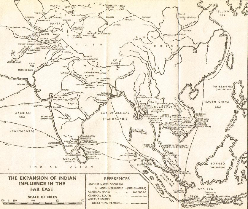
The idea of an ancient trade route to the east for spices and also precious metals like gold and silver is not new. The Jewish historian Josephus, writing in the first century AD, offered his explanation of the Biblical story of Solomon and Hiram’s joint trade mission to the distant land of Ophir. In his Antiquities of the Jews, he said the voyages which began from the Red Sea port of Ezion-geber were destined for the island of Chryse far to the east in the Indian Ocean. Ezion-geber was near the modern city of Eilat in Israel and the trade voyages took three years to complete according to the Old Testament account2. Where then was the island of Chryse mentioned by Josephus? Greek geographers usually placed it east of the Ganges river mouth. Medieval writings placed it near where the Indian Ocean met the Pacific Ocean. In modern times, Chryse has been equated by scholars with the land known in Indian literature as Suvarnadvipa. Both Chryse and Suvarnadvipa mean “Gold Island.” The latter was also located in Indian writings well to the east of India in the “Southern Ocean” and is identified by most scholars with the Malay Archipelago (“the East Indies”).
Josephus’ theory of voyages to Southeast Asia was supported indirectly about a half-century later by Philo of Byblos who translated the History of Phoenicia by Sanchuniathon. This translation was originally considered a fraud by modern scholars, but discoveries from Ras Shamra in the Levant indicate Philo’s work was authentic. They are important because they come from a different historical source than the Old Testament account.
Philo records the Phoenician version of Solomon and Hiram’s trade mission to Ophir. What is interesting is how Philo’s account allows us to interpret some arcane Hebrew passages. He outlines journeys into the Erythraean Sea (Indian Ocean) that took three years to complete. The items brought back from the journey were apes, peacocks and ivory all products of tropical Asia and all included along with other goods in the Biblical account.
Philo’s interpretation of Sanchuniathon’s history uses words for the products of the voyages which clearly point to tropical Asia unlike the strange terms used a thousand years earlier in Solomon’s time. The romantic idea of distant Ophir may have inspired the explorer Magellan on his circumnavigation voyage around the world in the 16th century. The explorer replaced geographical locations in his reference books with the names “Tarsis and Ofir,” the equivalent in his time of Biblical “Tarshish and Ophir.”3 He actually set a course on the latitude of one of these locations before reaching the islands of the Visayas from the East.
In the medieval and early colonial period, commentators on classical Greco-Roman literature first began hinting that the Cinnamon Route might trace eventually from Africa to the east in Asia. Many of the terms used for spices in early works are obscure and can be difficult to identify. The commentators interpreted these terms into the contemporary language at a time when the knowledge of the world had greatly increased. In most cases, we can confidently associate these latter spice names with species that we know today.
Thus, when the ancient writer Pliny mentions tarum as a product of East Africa we understand it as aloeswood because later commentators translate tarum with a word that is no longer obscure: lignum aloe “aloeswood.” By the time of the commentators, the source of the aloeswood was already well-known. Pliny mentions tarum as coming from the land that produced cinnamon and cassia in Africa. But the commentators give it an identity which clearly indicates a tropical Asian origin in their time.
So why were these Asian products turning up in African markets? Pliny is the only writer who attempts an explanation and the related passages have been the source of much scholarly controversy. The details will be discussed later in this book, but the historian James Innes Miller was possibly the first modern scholarto put on his glasses and use Pliny and other evidence to suggest that Austronesian traders had brought spices to African markets via a southern maritime route. Miller connected the spice route with the prehistoric settlement of Madagascar by Austronesian seafarers. spices from southern China and both mainland and insular Southeast Asia were brought by Austronesian merchants whom he associates with the people known to the Chinese by the names Kunlun and Po-sse.
Miller’s book was the defining work of his time and it still has a profound influence on historians of trade and seafaring. However, classical historians and philologists had mixed views on Miller’s thesis. A number of alternative theories sprung up and Miller was criticized, sometimes rightfully so, with using too many loosely-established ideas to support his argument. One of our main goals will be to use newer evidence along with some apparently missed by Miller to show that, for the most part, his idea of a southern transoceanic route was correct.
In addition to Miller’s Cinnamon Route, there also existed a “Clove Route” to China and India.
The evidence for these early spice routes comes from every available field including history, archaeology, linguistics, genetics and anthropology. For example, we can show by a process of elimination that a southern route for tropical Asian spices into Africa is historical. The exact details of this route are not known to us from history but the route itself is the only reasonable conclusion given the historical sources at our disposal. We can then bolster the testimony of history by bringing in supporting evidence from other fields.
One way we do this is to show that certain cultural items that came from Southeast Asia, or at least tropical Asia, were diffused first to the southeastern coast of Africa before moving northward at dates that are supportive of our thesis. One example is the diffusion of the domestic chicken (Galllus gallus) to Africa. The oldest archaeological remains of this species may date back to 2,800 BCE from Tanzania.4 The earliest similar evidence in Egypt is not earlier than the New Kingdom period about 1,000 years later. To support this finding, there is additional evidence provided by the presence of the double outrigger5barkcloth, various types of musical instruments6 and other cultural items present on the southeastern African coast. Possibly also the distribution of the coconut crab7, the world’s largest land-based invertebrate also provides evidence for this early southern contact.
An important factor in ascertaining the old spice routes from Southeast Asia is the trail of cloves from Maluku and the southern Philippines north to South China and Indochina and then south again along the coast to the Strait of Malacca. From there the cloves went to India spice markets and points further west. This north-south direction of commerce through the Philippines has recently been recognized by UNESCO as part of the ancient maritime spice route. The Philippine-Maluku hub persisted into Muslim times and is chronicled in Arabic historical and geographic writings.
While the clove route started in the south, cinnamon trade began in the north. The cinnamon route started in the cinnamon and cassia-producing regions of northern Indochina and southern China and then likely proceeded from South China spice ports southward during the winter monsoon down the Philippine corridor. The route likely turned southeast at that point to Sumatra and/or Java to pick up different varieties of cinnamon and cassia along with aloeswood and benzoin. From southwestern Indonesia the voyage then took the Austronesian merchants across the great expanse of the Indian Ocean to Africa.
Linguistically the clove route is supported by the distribution of names for ginger in the Malay Archipelago. These appear to have followed the clove route from China through the Philippines to the rest of insular Southeast Asia.
In the medieval Chinese and Muslim texts we first get specific details about these routes although they probably were unchanged from the ones used centuries or thousands of years earlier. The Chinese records in particular give detailed itineraries including directions and voyage length for each stop along the way to the southern spice markets. Of particular importance are the entrepots known to the Chinese as Sanfotsi and Toupo. The same marketplaces were likely known to the Muslim geographers likely by the names of Zabag and Waqwaq respectively.
Like Chryse of the Greeks and Suvarnadvipa of the Indians, these entrepots were a source of wonder and literary romance. In the One Thousand and One Nights, Sinbad travels to Zabag on one of his voyages and the islands of Waqwaq are the setting for the adventure of Hassan of Basra. Indian literature also abounds in tales of voyages to the islands of gold by those in search of treasure, either material or spiritual.
From the Arabic literature, we start to learn of first-hand accounts of trade and other voyages by mariners from Southeast Asia to Africa. Previously, we had only the vague accounts of Solomon’s journey and Pliny’s brief descriptions of long sea voyages from or to the cinnamon country. The Muslim works tell us of ships and people from Zabag and Waqwaq coming to African ports for trade and even on occasion to conduct military raids. The records give the impression of well-established trade relationships, but just how long did these long-distance ties exist before the Muslim writings?
We believe is a strong case for this trade opening up by at least the New Kingdom period in Egypt. At that time, voyages to the divine land of Punt became more frequent with large fleets bringing back impressive hauls of tribute for the Pharaoh. While the hard evidence is still fragmentary, the quantity and quality of this evidence is still comparable to those of other established theories. We simply come to the most logical conclusions based on the historical records, and how these records should be interpreted based on the evidence.
Rome’s discovery of the monsoon trade winds did not have any significant impact as the Roman ships mainly plied the waters between the Ptolemaic port of Berenike and the ports along the coast of eastern Africa and western India. The Romans apparently did not interfere much at these ports and only established minor trading colonies if any in these areas. The wave of Islam into East Africa was probably the strongest factor in closing the southern spice route.
Muslim traders managed to convert the local populations, and in the process, must have greatly complicated preexisting trade relationships. The Muslim merchants in their dhows moving eastward would have eventually discovered the sources of cinnamon and cassia. Then it was only a matter of time before the caliphate would be able to eliminate the African ports in favor of direct import to Arab entrepots. This was not an immediate process though.
The Muslim geographers and historians still record trade activity between Africa and Southeast Asia in aloeswood, tortoise-shell, iron and other products centuries after the Arabs had established themselves on the Tanzanian coast. By the time the Portuguese reached this area though it appears this trade had disappeared. All that was left were traces of the Austronesian contact including the local boats with their outriggers and lateen sails made of coconut fiber.
With the end of the cinnamon route and the advent of the European control of the spice trade, the Austronesian component of this commerce almost completely faded away. However, some three thousand years of spice trade from the New Kingdom to the late Muslim period left a lasting legacy that reshaped the world. The vision of an El Dorado of gold and spices tempted romantics and kings alike. For centuries, the Arabs had controlled the Mediterranean part of the spice trade by keeping secret the monsoon sources of the precious commodities. Eventually the Roman empire discovered the monsoon routes as opposed to earlier costly voyages that involved closely following the shoreline. However, it took some time before they could discover the real sources of the spices they treasured so much.
When the Alexandrian merchant Cosmas Indicopleustes ventured to find these sources in the sixth century ACE, many of these secrets were just coming to light. However, it was a little too late. The meteoric rise of Islam closed off any further European exploration or exploitation of the spice routes. Conversely, a whole new world was opened up for the merchants of the Muslim world. Their newly found power allowed them to venture deep into Asia as never before. The Islamic texts give the first detailed descriptions of the emporiums of the East. By at least the ninth century, a massive trade ensued between the two regions greatly enriching the the Islamic caliphate. Magnificent cities and buildings were constructed throughout the Muslim lands at the same time that Europe sunk into the dark ages. The Arabic writers also tell of great kingdoms and empires of the East including the fabled cities of the Khmers and the island domains of the Mihraj (Maharaja) of Zabag.
Europe would get another chance centuries later when a charismatic leader arose out of a hitherto unknown nomadic tribe of the steppe. Chingiss Khan, also known as Genghis Khan, rode out of the wastelands of Central Asia with his Mongol armies on epic conquests. Among the empires destroyed in the Great Khan’s path was the Islamic Caliphate. The fall of Baghdad again opened the Silk Road and the maritime spice route to the merchants and adventurers of Europe. One of the first to take up the challenge of the East was Marco Polo. The records of his travels along with those of other Europeans who ventured east rekindled the urge to link with the long-lost spice Eden of the east. The Portuguese were the first to take up the gauntlet establishing bases at Goa in India and Malacca on the Malay Peninsula. Others followed including the powerful Dutch East Indian Company.
The quest for spices and precious metals ushered in what is known as the Age of Exploration. Magellan’s personal documents indicated his desire to find the golden islands of Tarshish and Ophir. The explorer Sebastian Cabot was appointed as commander of an expedition “to discover the Moluccas, Tarsis, Ophir, Cipango and Cathay.” The fight to control the flow of cloves, nutmeg, black pepper, gold, silver and other commodities led to the circumnavigation of Africa and the world, and the exploration of the Western hemisphere and the Pacific Ocean.
The coming of the Europeans nearly completely excluded the native Austronesian merchants from the trade. The same people who in the Muslim annals were sailing to East Africa to engage in commerce now where often prevented even from participating in merchant activity from city to city or island to island in their own region. Only after Southeast Asia freed itself from Western colonialism has this ancient wonderland of entrepots regained direct control its own trade again. Today, the nations of the Association of Southeast Asian Nations (ASEAN) have formed a unique organization designed to enhance commerce in the region. Indeed, ASEAN is really the model for the entire Asian region. Even developed Asian nations like Japan and South Korea have looked to ASEAN as the model for regional trade cooperation.
Today, manufactured goods from sneakers to computers are more important exports that spices or precious metals, although these latter items continue to hold their own. The region has also come to be a leader in a completely different type of trade – the human trade. Southeast Asia is the world’s largest exporter of human labor. Seafarers , nurses, doctors, domestics, constructions workers, computer programmers and almost every other kind worker including those in illegal trades come from the Philippines, Thailand, Indonesia, Cambodia or other nations in the area and can be found in almost every country of the world.
Many analysts believe the geopolitics of the area will again bring Southeast Asia to the center of the world’s stage. Most of the goods shipped around the globe still travel by sea, and Southeast Asia is the main hub for trade between Asia and the rest of the world. The volume of trade activity has been growing faster here than any other area of the world and most expect this trend to continue. The region’s great natural diversity may again come into play as the ageing populations of the developed world look for new medicines and natural cures from Southeast Asia’s biological resources.
According to one theory, the great Austronesian migrations of prehistory began with the flooding of the Sundaland continent, which also created the islands of the Malay Archipelago. The region’s natural treasures provided the wayfaring Austronesians with items of the trade that became valued in distant lands. Then, as now, a combination of natural forces thrust the people of Southeast Asia into a crucial role in the course of world history.


The Clove RouteAccording to Chau Ju-Kua, cloves and nutmeg were grown in two kingdoms found in Toupo, southeast of southern China.
Ships coming from Toupo to China sailed for twenty-five days on a northwest course before arriving at Sanfotsi, and from there proceeded either due to north to reach Tsu'an-chou (Fuzhou or Xiamen) or a bit northwest to reach Canton.
So it is clear and logical that the clove route went through the Philippines, where Sanfotsi was located and this also was the most direct course for the trade between the clove and nutmeg-bearing regions with the Chinese coast.


Share article:   Facebook   MySpace   Send by Email   
Related links
More on the Clove Route
More on Clove and Cinnamon Routes
New evidence of Cinnamon Route from Mtwapa, Kenya

Serlingpa: King of Suvarnadvipa

Wednesday, February 10, 2016

agusan river

featured_slider-Agusan_River_Cruise

sanscrit influences


====================================================================

A Sanskrit-Chinese dictionary compiled in Central Asia in the seventh and eighth centuries calls the countries situated in the Southern Seas as Jipattala which Sylvain Levi interprets as the Indian archipelago and the neighboring islands. These two Indias were called by the name of Bharatavarsha which included the nine islands ofDvipantara-Bharata, each separated from the other by sea. The names of those islands were Indra-dvipa, Kaseru, Tamravarna, Gabhastiman, Nagadvipa, Saumya, Gandharva and Varuna. 

Masudi
, 
born in Baghdad, the Arab geographer, historian and philosopher, states in his work called Muruj adh-Dhahab  or'Meadows of Gold' written in 942 A.D. that India in those days "extended over sea and land and bordered on the country called Zabag (Sumatra or Greater Java) ruled by the king of these islands."

Professor Sylvain Levi has shown from references in theRamayana, Mahabharata, Mahaniddesa, and Brihat-Katha that the products of Burma and Malaya Peninsula were known to Indian merchants and sailors, and also some of its ports such as Suvarnakudya, Suvarnabhumi, Takkolam, Tamlin and Javam from at least first century A.D. 
The Periplus of the Erythrean Sea written by a Greek sailor of Egypt in the first century A.D. mentions many ports of India then existing on its Western and Eastern coasts. Ptolemy in his Geography written in the second century A.D. refers to the ports of Malaya Peninsula, Java, and Sumatra and the Indian port of Palura from which voyages were directly made to Malaya Peninsula. Ptolemy's reference in the second century to Iabadiou certainly represents the Prakrit from of the Sanskrit Yavadvipa.

Indian culture flourished, reaching islands as far as Borneo and Bali. Some of it survives even today, evident from the quaint proto-Sanskritic names that still prevail in Thailand, Malaysia, Cambodia and Indonesia. Borneo's capital, Bandar Seri Begawan is a colloquialisation of Sri Bhagwan, Bali's headquarters, Jeyapora, is nothing but Jaipur, localised, just as Aranya Prathet in Thailand is simply the jungle province or Aranya Pradesh. Fortunately, much of the structure of the gigantic temple city of Angkor Vat has survived the ravages of the Khmer Rouge, while Borobudur in Java still shines in resplendent glory.
"A Tamil inscription found in Thailand, at the site of Takua Pa, testifies to southeast Asia commerce with the Pallava region. A poem written by the 8th century Vaishnava saint, Tirumangai, speaks of ports where "ships rode at anchor, bent to the point of breaking, laden as they were with wealth, with big-trunked elephants, and with mountains of gems of nine varieties." 

(source: Indian Art - By Vidya Dehejia  p. 186).
Names like Indo-China. Further India, Insulindia, Indonesia, etc., which are applied to various parts of South East Asia and the Far East are as significant as 'Ser-Inida.' This region is geographically an extension of India and Ptolemy rightly calls it 'Trans-Gangetic India.'
(source: Cultural Heritage of Ancient India - By Sachindra Kumar Maity p.121). For a virtual tour of extensive art from Southeast Asia, visit

Suvarnadvipa,

Zabag (Chinese: Sanfotsi; Hindu: Suvarnadvipa, Javaka; Arabic: Zabaj) is thought to have been an ancient kingdom located south of China somewhere in Southeast Asia, between Chenla (now Cambodia) and Java. The established studies by several historians associated this kingdom with Srivijaya and pointed its location somewhere in SumatraJava or Malay peninsula. However its exact location is still the subject of debate among scholars. Other possible locations such as northernBorneo and Philippines are also suggested.[1]  


Sanfotsi lies between Chenla and Toupo (Chopo or Java). Its rule extend over fifteen chou. It lies due south of Tsu'an-chou. In the winter, with the monsoon, you sail a little more than a month and then come to Lingyamon, where one-third of the passing merchants before entering this country of Sanfotsi.
A large proportion of the people are surnamed P'u .
The people either live scattered about outside the city, or on the water on rafts of boards covered over with reeds, and these are exempt from taxation.
They are skilled at fighting on land or water. When they are about to make war on another state they assemble and send for the such a force as the occasion demands. They appoint chiefs and leaders, and all provide their own military equipment and the necessary provisions. In facing the enemy and braving death they have not their equal among other nations.
During most of the year the climate is hot, and there is but little cold weather. Their domestic animals are very much like those ofChina. They have wine of flowers, wine of coconuts, and wine of areca nuts and honey, all fermented, though without any yeast of any kind, but they are so intoxicating to drink.[2]
  • Chou Fu-kei hundreds of years later says the same thing:
Sanfotsi is in the Southern Ocean (South China Sea). It is the most important port-of-call on the sea-routes of the foreigners from the countries of Toupo on the east and from the countries of the Arabs and Kulin to the west; they all pass through on the way to China.
The country has no natural products, but the people are skilled in fighting. When they are about to fight, they cover their bodies with a medicine which prevents swords wounding them (amulets). In fighting on land or on water none surpass them in impetousity of attack; even the Kulin people come after them. If some foreign ship, passing this place, should not enter here, an armed party would certainly come out kill them to the last.[2]

LOCATION

SRIVIJAYA

Many historian identify Zabag with Srivijaya, a maritime empire centered inSumatra. A French scholar George Coedès published his discoveries and interpretations in Dutch and Indonesian-language newspapers.[3] Coedès noted that the Chinese references to "Sanfoqi" or "Sanfotsi", previously read as "Sribhoja", and the inscriptions in Old Malay refer to the same empire.[4]
Srivijaya and by extension Sumatra had been known by different names to different peoples. The Chinese called it Sanfotsi or San Fo Qi, and at one time there was an even older kingdom of Kantoli that could be considered as the predecessor of Srivijaya.[5][6] In Sanskrit and Pali, it was referred to as Yavadesh and Javadeh respectively.[5] The Arabs called it Zabag and the Khmer called it Melayu.[5] This is another reason why the discovery of Srivijaya was so difficult.[5]While some of these names are strongly reminiscent of the name of Java, there is a distinct possibility that they may have referred to Sumatra instead.[7]

OTHER LOCATIONS

LOCATION OF TOUPO

"Ye-po-ti of Fashien and Choup'o of the Gunavarman story with Java though probable ,is not accepted by all scholars"{[8]
"Two weeks before reaching Poni by sea" -Chinese works.[8]
Modern Historian are now pointing Cotabato Delta as the Medieval location of Toupo,the successor of Maguindanao/Cotabato Sultanate.[8]

EXTERNAL LINKS

  • The Medieval Geography of Sanfotsi and Zabag
HELP IMPROVE THIS ARTICLE
Sourced from World Heritage Encyclopedia™ licensed under 
Help to improve this article, make contributions at the Citational Source

This article was sourced from Creative Commons Attribution-ShareAlike License; additional terms may apply. World Heritage Encyclopedia content is assembled from numerous content providers, Open Access Publishing, and in compliance with The Fair Access to Science and Technology Research Act (FASTR), Wikimedia Foundation, Inc., Public Library of Science, The Encyclopedia of Life, Open Book Publishers (OBP), PubMed, U.S. National Library of Medicine, National Center for Biotechnology Information, U.S. National Library of Medicine, National Institutes of Health (NIH), U.S. Department of Health & Human Services, and USA.gov, which sources content from all federal, state, local, tribal, and territorial government publication portals (.gov, .mil, .edu). Funding for USA.gov and content contributors is made possible from the U.S. Congress, E-Government Act of 2002.
 
Crowd sourced content that is contributed to World Heritage Encyclopedia is peer reviewed and edited by our editorial staff to ensure quality scholarly research articles.
 
By using this site, you agree to the Terms of Use and Privacy Policy. World Heritage Encyclopedia™ is a registered trademark of the World Public Library Association, a non-profit organization.


Peleg" means a dividing


................................................

In the Hebrew language the name "Peleg" means a dividing by a "small channel of water" and is also root associated with the meaning of an earthquake. The Hebrew word translated as "divided" in the passage means to "split" something. According to the Bible genealogy, this man named Peleg was born 101 years after the flood. No doubt this Peleg was so named because of an event of great significance to the people living at the time he was born. The fact that this dividing event is mentioned by the Holy Spirit in TWO places in the Scriptures, and that the EXACT number of years between this event and the flood is also recorded, alludes to the importance of these passages in the interpretation of post-flood history.
Some Creationists have interpreted this event to be the division of the North and South American continents from the European and African continents by the Atlantic Ocean after the flood. But a division of such magnitude at that point in geologic time would invalidate our previously proposed flood model. It would also invalidate accepted paleomagnetic data which supports gradual sea floor spreading at the mid-Atlantic ridge. Besides, the Atlantic Ocean is no "small channel of water" between land masses. Obviously, that is not the answer we are looking for.
After examining the Hebrew meanings, a more plausible alternative interpretation would be that it describes an earth-splitting event such as a valley opening in the ground and filling with water. That could have happened anywhere along the Dead Sea Rift zone (discussed in detail later) and may have been associated with a delayed adjustment of the Earth's plates in response to the rapid subsidence of the sea floors by the flood.
In theory, when the weight of the waters of the flood forced the sea floors downward to fill the void left in the magma chambers beneath, strain would have developed between the oceanic and continental portions of the crustal plates. Consequently, tectonic pressures were redistributed. About 100 years later the strain and pressure redistribution may have caused the Earth's crust to rapidly rent in weaker places, much like a piece of ridged plastic which can be stretched and deformed. It will eventually snap if the strain remains constant. An abrupt further change in sea levels could possibly accompany such an event.
Looking at world relief and tectonic maps, one possible location of the effects of this Peleg event is found in Middle East. It is called the Afar Triangle.  

The Afar fracture is a three-way split, which some geologists believe is caused by an upwelling magma plume, for lack of a better engine. The area on the African continent running south-west from that fracture locus is the Great African Rift Valley which runs down into the middle of the African continent. The area going north runs along the bottom of the Red Sea, up into the Dead Sea Rift area of Israel, up the Jordon river valley, and continues northward. This Peleg event is most likely a local reference to a widening of that Rift somewhere near or north of Israel.
The next image is a view of the Afar Triangle's tectonic features. In all likelihood, this Rift system was already active before Noah's flood, but Noah's flood triggered renewed activity. I state that because the path of the Rift from Israel continues to run south for the entire length of Ethiopia. It seems to match the described path of the river Gihon, one of four that flowed from the 

"And the name of the second river is Gihon: the same is it that compasseth the whole land of Ethiopia."
(Genesis 2:13 KJV)
If that is true, then there has been considerable tectonic activity since the Garden of Eden, and Noah's flood may have been just a contributing driver of latter changes.
Now, as for how man and animals got to places like Australia and the Americas, it is possible that they migrated there on dry land during the 101-year interval between the flood and the subsequent plate settling. Possibly, sea levels may have risen quite a bit since the post-flood migrations began, and even more after the Days of Peleg. An examination of the geology of the region between Indochina and Australia shows that the sea between the two continental masses is relatively shallow.


The same is true of the Bearing Straits separating Alaska from Russia, where the waters are only about 50 feet deep between the tip of Asia and North America. It is theoretically possible that in the 101 years following the flood, and before the events of Peleg's days, narrow land bridges (which today are submerged) may have still existed between many places across the globe. The fact that the ruins of many ancient cities in the Mediterranean Sea area, which postdate the time of Noah's flood and are found underwater today, tells us that global sea levels have increased by several meters since those cities were built, or there has been wide-spread subsidence since then. Regardless, an appeal to present-day sea levels is not a valid argument against post-flood migrations to regions now inaccessible across dry land.
Assuming that some land bridges existed briefly after the flood by whatever mechanism, the question is: Did man and beast have sufficient time to migrate from the resting place of the Ark to other continents before the dividing? Well, let's do the math:
If you calculate the distance from eastern Mesopotamia to the tip of Australia and divide it by 100 years, you will find that both man and beast would only have to migrate less than 80 miles a year (0.21 miles a day) in order to reach Australia; less than 55 miles a year (0.15 miles a day) to reach North America via the Bearing Straits; and less than 48 miles a year (0.13 miles a day) if a land bridge (or possibly an ice bridge) existed across the northern polar regions. Those average daily distance requirements are much less than most people walk each day in their normal routines. The data support the Scriptures.
"These [are] the three sons of Noah: and of them was the whole earth overspread."
(Genesis 9:19 KJV)
 Shortly after the Ark landed on the mountains of Ararat, the families of mankind spread across the world. At that point in time mankind all spoke a common language and the bulk of them appear to have migrated westward, although it is safe to assume that some settled near the place where the Ark came to rest, and the oral tradition of Gilgamesh and the flood probably originated with the latter. Those people who did migrate westward are spoken of in Genesis 11:1-2:
"And the whole earth was of one language, and of one speech. And it came to pass, as they journeyed from the east, that they found a plain in the land of Shinar; and they dwelt there."
(Genesis 11:1-2 KJV)
That land of Shinar is Babel (Babylon), and there the Bible says the Lord confounded their language and from there they scattered out across the face of the Earth.

Genealogy of the Descendants of Shem: Noah and his Sons divide the Earth (viii. 1-30; cf. Gen. x.).

Genealogy of the Descendants of Shem: Noah and his Sons divide the Earth (viii. 1-30; cf. Gen. x.).


VIII. In the twenty-ninth jubilee, in the first week, 
1373 A M.
in the beginning thereof Arpachshad took to himself a wife and her name was Râsû’ĕjâ, [the daughter of Sûsân,] the daughter of Elam, and she bare him a son in the third year in this week, and he called his name 
1375 A.M.
Kâinâm. 5 2. And the son grew, and his father taught

p. 72
him writing, and he went to seek for himself a place where he might seize for himself a city. 3. And he found a writing which former (generations) had carved on the rock, and he read what was thereon, and he transcribed it and sinned owing to it; for it contained the teaching of the Watchers in accordance with which they used to observe the omens of the sun and moon and stars in all the signs of heaven. 1 4. And he wrote it down and said nothing regarding it; for he was afraid to speak to Noah about it lest he should be angry with him on account of it. 5. And in the thirtieth jubilee, in the second week, in the 
1429 A.M.
first year thereof, he took to himself a wife, and her name was Mêlkâ, the daughter of Madai, the son of 
1432 A.M.
Japheth, and in the fourth year he begat a son, and called his name Shelah; 2 for he said: "Truly I have been sent." 3 6. [And in the fourth year he was born], and Shelah grew up and took to himself a wife, and her name was Mû’ak, the daughter of Kêsêd, his father's brother, in the one and thirtieth 
1499 A.M.
jubilee, in the fifth week, in the first year thereof. 7. And she bare him a son in the fifth year thereof, and he called his name Eber: and he took unto 
1503 A.M.
himself a wife, and her name was ’Azûrâd 4 the daughter 
1564 A.M.
of Nêbrôd, in the thirty-second jubilee, in the seventh week, in the third year thereof. 8. And in the sixth 
1567 A.M.
year thereof, she bare him a son, and he called his name Peleg; for in the days when he was born the children of Noah began to divide the earth amongst themselves: for this reason he called his name Peleg. 5 9. And they divided (it) secretly 6 amongst themselves,


p. 73
and told it to Noah. 10. And it came to pass in the beginning of the thirty-third jubilee that they divided 
1569 A.M.
the earth into three parts, for Shem and Ham and Japheth, according to the inheritance of each, in the first year in the first week, when one of us, 1 who had been sent, was with them. 11. And he called his sons, and they drew nigh to him, they and their children, and he divided the earth into the lots, which his three sons were to take in possession, and they reached forth their hands, and took the writing out of the bosom of Noah, their father. 12. And there came forth on the writing as Shem's lot 2 the middle of the earth 3 which he should take as an inheritance for himself and for his sons for the generations of eternity, from the middle of the mountain range of Râfâ, 4 from the mouth of the water from the river Tînâ. 5 and his portion goeth towards the west through the midst of this river, and it extendeth till it reacheth the water of the abysses, out of which this river goeth forth and poureth its waters into the sea Mê’at, 6 and this river floweth into the great sea. And all that is towards the north is Japheth's, and all that is towards the south belongeth to Shem. 13. And it extendeth till it reacheth Kârâsô: 7 this is in the bosom of the tongue 8 which looketh towards the south. 14.


p. 74
[paragraph continues] And his portion extendeth along the great sea, and it extendeth in a straight line till it reacheth the west of the tongue which looketh towards the south; 1for this sea is named the tongue of the Egyptian Sea. 2 15. And it turneth from here towards the south towards the mouth of the great sea 3 on the shore of (its) waters, and it extendeth to the west to ‘Afrâ 4 and it extendeth till it reacheth the waters of the river Gihon, and to the south of the waters of Gihon, 5 to the banks of this river. 16. And it extendeth towards the east, till it reacheth the Garden of Eden, to the south thereof, [to the south] and from the east of the whole land of Eden and of the whole cast, it turneth to the †east,† 6 and proceedeth till it reacheth the east of the mountain named Râfâ, and it descendeth to the bank of the mouth of the river Tînâ. 17. This portion came forth by lot for Shem and his sons, that they should possess it for ever unto his generations for evermore. 18. And Noah rejoiced that this portion came forth for Shem and for his sons, and he remembered all that he had spoken with his mouth in prophecy; for he had said:
Blessed be the Lord God of Shem,
And may the Lord dwell in the dwelling of Shem." 7

[paragraph continues] 19. And he knew that the Garden of Eden is the holy of holies, and the dwelling of the Lord, and Mount Sinai the centre of the desert, and Mount Zion--the centre of the navel of the earth: these three 8 were created as holy places facing each other. 20. And he blessed the God of gods, who had put the word of the Lord into his mouth, and the Lord for evermore. 21. And he knew that a blessed portion


p. 75
and a blessing had come to Shem and his sons unto the generations for ever--the whole land of Eden and the whole land of the Red Sea, and the whole land of the east, and India, and on the Red Sea and the mountains thereof, and all the land of Bashan, and all the land of Lebanon and the islands of Kaftûr, 1 and all the mountains of Sanîr 2 and ’Amânâ, 3 and the mountains of Asshur in the north, and all the land of Elam, Asshur, and Bâbêl, and Sûsân and Mâ‘ĕdâi 4 and all the mountains of Ararat, and all the region beyond the sea, which is beyond the mountains of Asshur towards the north, a blessed and spacious land, and all that is in it is very good. 22. 5 And for Ham came forth the second portion, beyond the Gihon towards the south to the right 6 of the Garden, and it extendeth towards the south and it extendeth to all the mountains of fire, 7 and it extendeth towards the west to the sea of ’Atêl 8 and it extendeth towards the west till it reacheth the sea of Mâ’ûk 9--that (sea) into which †everything which is not destroyed descendeth†. 10 23. And it goeth forth towards the north to the limits of Gâdîr, 11 and it goeth forth to the coast of the waters of the sea to the waters of the great sea till it draweth near to the river Gihon, and goeth along the river Gihon till it reacheth the right of the Garden of Eden. 24. And this is the land which came forth for Ham as the portion which he was to occupy for ever for himself and his sons unto their


p. 76
generations for ever. 25. 1 And for Japheth came forth the third portion beyond 2 the river Tînâ 3 to the north of the outflow of its waters, and it extendeth north-easterly to the whole region of Gog 4 and to all the country east thereof. 26. And it extendeth northerly to the north, and it extendeth to the mountains of Qêlt 5towards the north, and towards the sea of Mâ’ûk, and it goeth forth to the east of Gâdîr as far as the region of the waters of the sea. 27. And it extendeth until it approacheth the west of Fârâ 6 and it returneth towards ’Afêrâg, 7 and it extendeth easterly to the waters of the sea of Mê’at. 8 28. And it extendeth to the region of the river Tînâ in a northeasterly direction until it approacheth the boundary of its waters towards the mountain Râfâ, 9 and it turneth round towards the north. 29. This is the land which came forth for Japheth and his sons as the portion of his inheritance which he should possess for himself and his sons, for their generations for ever; five great islands, 10 and a great land in the north. 30. But it is cold, and the land of Ham is hot, and the land of Shem is neither hot nor cold, but it is of blended cold and heat.


Footnotes

71:5 This name occurs in the LXX of Gen. xi. 13, but not in the MT or other Versions. It also occurs in the genealogy in Luke iii. 36.
72:1 Cf. Josephus, Ant. i. 2, 3, who assigns this wisdom not to the Watchers, but to the children of Seth.
72:2 Cf. Gen. X. 24.
72:3 A paronomasia is implied in the original Hebrew here.
72:4 Read ’Azûrâ.
72:5 There is a play (in the original Hebrew) on the meaning of the name Peleg here.
72:6 The secret division of the earth is followed by an authoritative one by Noah, and made binding on his descendants. Canaan is included in Shem's lot. Hence, the Israelite conquest p. 73 later is justified. 'Noah's division of the earth is alluded to in Pirḳe de R. Eliezer xxiii. (end).
73:1 i. e. one of the angels.
73:2 For the countries included in Shem's lot, See 21, ix. 2-6, 13b. According to Epiphanius it extended from Persia and Bactria to India, to Rhinocurura (between Egypt and Palestine).
73:3 According to Ezek. xxxviii. 12 (1 Enoch xxvi. i) Palestine was the "navel" of the earth.
73:4 Probably the Rhipaean mountains (identified sometimes with the Ural mountains).
73:5 i. e. the river Tanais or Don.
73:6 i. e. the Maeotis or Sea of Azov.
73:7 i. e. (?) the Rhinocurura (= "the torrent of Egypt") on the confines of Egypt and Palestine (Charles); cf. Isa. xxvii. 12.
73:8 i. e. either promontory of land, or bay.
74:1 i. e. (?) the promontory on which Mt. Sindi is situated.
74:2 I i. e. the Gulf of Akaba; cf. Isa. xi. 15.
74:3 ? the northern waters of the Red Sea.
74:4 i. e. Africa in the restricted sense of the Roman province which included Egypt and the other northern parts of Africa bordering the Mediterranean.
74:5 i. e. the Nile.
74:6 ? read "west."
74:7 Cf. vii. 11.
74:8 These three holy places fall within Shem's lot.
75:1 ? Crete. The ancient Versions identify Caphtor with Cappadocia.
75:2 i. e. Senir (Deut. iii. 9; Ezek. xxvii. 5) = Hermon.
75:3 ? Mt. Amanus in N. Syria.
75:4 i. e. Media; cf. x. 35.
75:5 22-24 give details of Ham's portion, which includes all Africa and certain parts of Asia.
75:6 i. e. to the south.
75:7 Cf. 1 Enoch xviii. 6-9, xxiv. 1-3.
75:8 i. e. the Atlantic.
75:9 ? The great ocean stream in the extreme west.
75:10 The text may be corrupt. Render, perhaps, "if anything descends into it, it perishes" (Charles).
75:11 i. e. Cadiz.
76:1 25-29a Japheth's portion (N. Asia, Europe, five great islands); cf. ix. 7-13.
76:2 Japheth's portion is elaborately described in Josephus, Ant. i. 6, 1.
76:3 i. e. the river Don.
76:4 In N. Asia. Josephus identifies Gog with the Scythians.
76:5 Qêlt = probably the Celts.
76:6 ? Africa.
76:7 ? Phrygia.
76:8 i. e. the Sea of Azov (see viii. 12 above).
76:9 ? the Ural mountains (Cf. viii. 12 above).
76:10 Including, probably, Cyprus, Sicily, Sardinia, Corsica.